M8.8 Kamchatka, Russia Great Earthquake on 30 July 2025
30 July 2025
Wilson WS Chan, David TW Hui
According to the Hong Kong Observatory’s analysis, a great earthquake of magnitude 8.8 occurred at 7:24 a.m. on 30 July 2025 (Hong Kong Time) off the coast of Kamchatka, Russia. The final revision of the earthquake magnitude was 8.8. It was a shallow earthquake with a focal depth of around 10 km. The epicentre was located approximately 110 kilometres east-southeast of Petropavlovsk-Kamchatsky, or about 5,140 km northeast of Hong Kong. This distant earthquake was not felt in Hong Kong. However, the seismograph station at Po Shan, Hong Kong did clearly detect the P-wave of this event at around 23:33UTC on 29 July 2025 (7:33 am on 30 July Hong Kong Time), approximately 9 minutes after the origin time (Figure 1). (HKT = UTC + 8 hours)
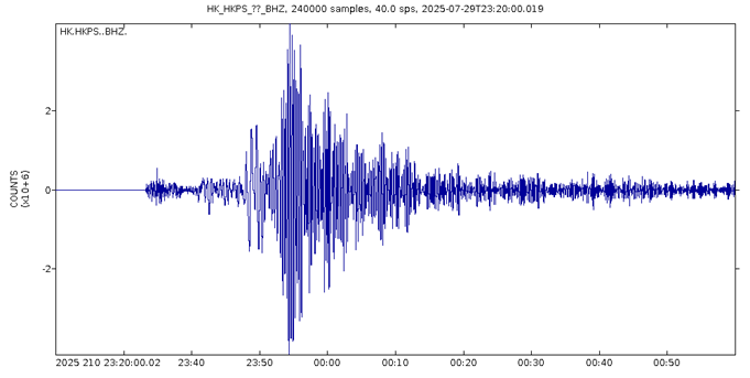
Figure 1 The seismic waves recorded at Po Shan station in Hong Kong
This Kamchatka great earthquake triggered tsunami. In Japan, tsunami waves of 1.3m, 0.8m and 0.4m were respectively recorded at Kujiko, Hachijojima and Nakanoshima during the day on 30 July 2025. Based on the Hong Kong Observatory’s Tsunami Travel Time Chart (Figure 2), the first tsunami wave was estimated to reach Hong Kong at around 5 p.m. on the same day. The tsunami heights of the first couple of waves were too low to be observed. Afterwards, the Observatory recorded sea-level anomalies of around 7 centimetres at about 6:40 p.m. and 7:16 p.m. that day at Shek Pik tide station (red circles in Figure 3), which was probably due to the arrival of subsequent tsunami waves. Subsequently, the following tsunami waves weakened gradually.
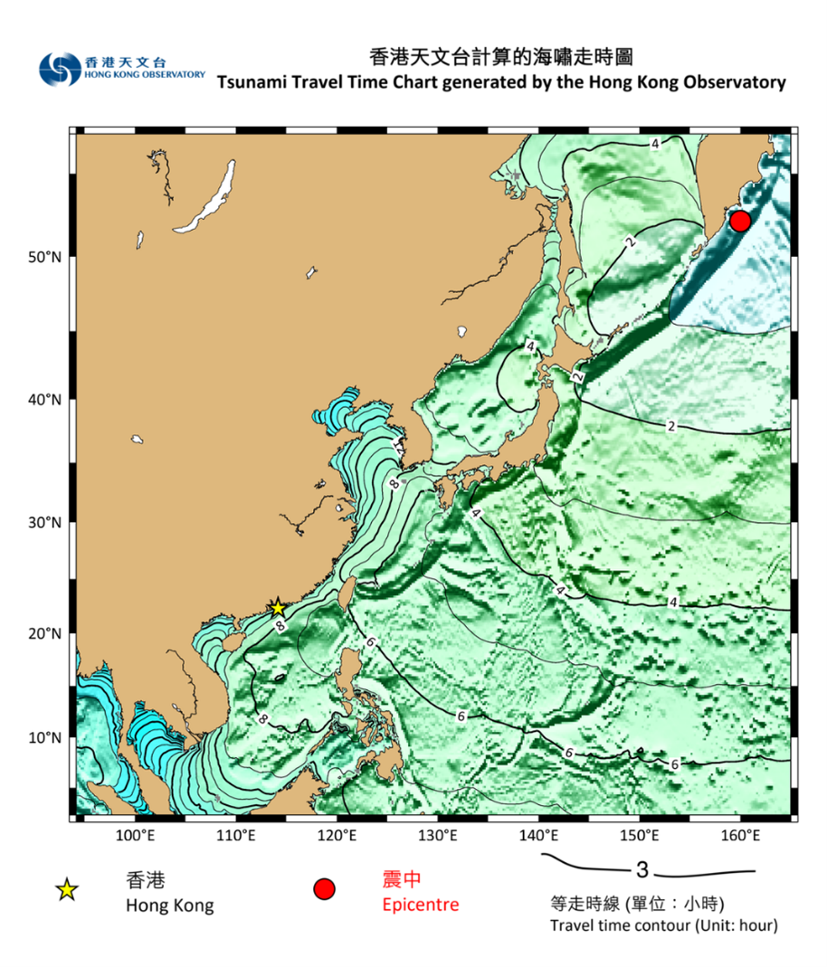
Figure 2 The Hong Kong Observatory’s Tsunami Travel Time Chart
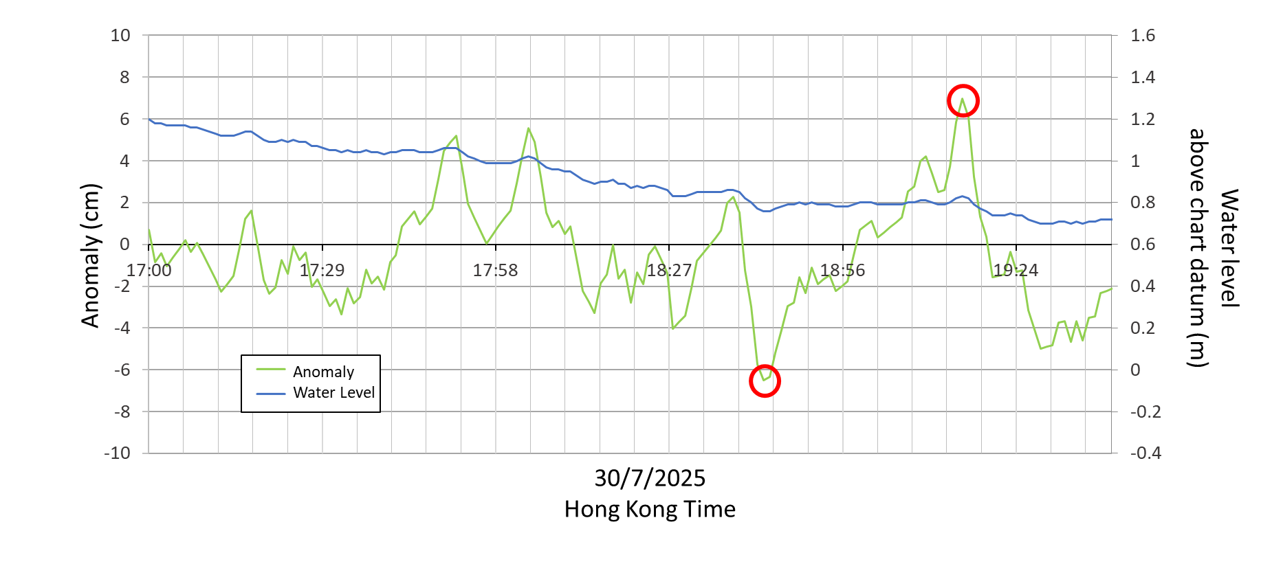
Figure 3 Time series of sea level data (blue line) and anomaly (green line showing filtered tidal variation by deducting 61-minute moving average). Red circles mark the maximum anomalies of 7cm.
Kamchatka, Russia, is situated at the convergent boundary between the North American Plate and the Pacific Plate (Figure 4), and in the northwestern segment of the Pacific Ring of Fire—a region prone to frequent seismic activity. At this tectonic junction, the Pacific Plate moves northwest relative to the North American Plate at a rate of approximately 80 mm per year, subducting beneath it [1, 2]. Large-magnitude reverse-fault earthquakes (Figure 5) in this area, particularly those occurring underwater at shallow depths, can release elastic energy that displaces seawater and generate tsunamis. Historical records show that the most powerful earthquakes, those of magnitude 9.0 or above, have all occurred along the Pacific Ring of Fire. Notably, Kamchatka experienced a M9.0 great earthquake on 4 November 1952 [3], which triggered a Pacific-wide tsunami. Even Hong Kong recorded a very minor water level anomaly of 0.15 m during that event.

figure 4: Tectonic Plate Configuration Map
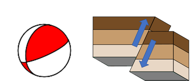
Figure 5: Focal mechanism of this earthquake (left) and the corresponding fault motion (right)
In addition to the use of computer numerical modelling to predict tsunami wave amplitudes, the Observatory closely monitors the water level data recorded by tide gauges and tsunami buoys across the western Pacific and the South China Sea. By analysing real-time water level changes near the tsunami source, we can estimate the tsunami wave height upon arrival (Figure 6). Furthermore, the Observatory will also closely monitor the latest information from the Pacific Tsunami Warning Center (PTWC) and the South China Sea Tsunami Advisory Center (SCSTAC).
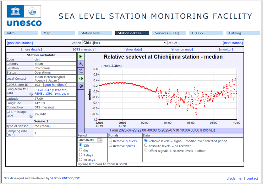
Figure 6 Water level fluctuations at Chichijima, Japan extracted from the Sea Level Monitoring Facility webpage [4] of the UNESCO Intergovernmental Oceanographic Committee
If Hongkongers travel abroad and encounter signs of any tsunami precursors (please refer to the blog on (“Earthquake and Tsunami Knowledge We Need to Know”), they should move away from the coastal or shallow waters to inland areas or higher ground as soon as possible. Those on land near the shore should seek shelter in high places or on the upper floors (above third level) of reinforced buildings. Do not wait for tsunami warning to take actions. Official warnings may be issued through a variety of channels including radio, mobile phone text messages, outdoor broadcasts, television announcements or telephone notifications. Tsunamis may strike repeatedly, so stay away from shores, beaches and low-lying coastal areas until the warning is officially lifted. If they are caught by the wave, cling to sturdy objects (like trees or railings) or large floating items to stay afloat. After a tsunami occurs, one still need to stay alert and pay attention to the environmental safety, avoid wading and approaching collapsed power lines or water-clogged areas.
References:
[1] United States Geological Survey (USGS)report on the M 8.8 - 2025 Kamchatka Peninsula, Russia Earthquak
[2] Gorbatov, A., Kostoglodov, V., Suárez, G., & Gordeev, E. (1997). Seismicity and structure of the Kamchatka subduction zone. Journal of Geophysical Research: Solid Earth, 102(B8), 17883-17898.
[3] United States Geological Survey (USGS) : 20 Largest Earthquakes in the World Since 1900
[4] The Intergovernmental Oceanographic Commission of UNESCO (UNESCO-IOC) "Sea level station monitoring facility" website