Developments and Prospects of Artificial Intelligence in Rainfall Nowcasting
26 March 2026
LEE Sung-ho, LEUNG Ka-fai, WONG Wai-kin
With the rapid advancement of artificial intelligence (AI) technology in recent years, the field of meteorological services are undergoing unprecedented transformation in observations, forecasting, and service development. At the same time, with the intensification of climate change and the increasingly frequent extreme weather events in recent years, how can AI contribute to the improvement in prediction and early warning of rainstorm?
Since the late 1990s, the Hong Kong Observatory (the Observatory) has developed an in-house nowcasting system, namely, SWIRLS (Short-range Warning of Intense Rainstorms in Localised Systems) which has been in operation since 1999 to support the forecasting of severe weather such as heavy rain and thunderstorms, as well as the operation of the rainstorm warning system. The fundamental principle of SWIRLS nowcast is to use two successive radar images taken every six minutes to calculate the moving direction and speed of radar echoes, and then to extrapolate the future positions of rain areas over the next few hours based on the calculation results. While extrapolation can effectively capture the movement trend of rain areas and performs reasonably well for a short forecast period such as one to two hours, it is unable to handle changes such as the development or dissipation of rain areas. As a result, there is still considerable room for improvement in both forecast location and intensity of rain areas for longer forecast periods.
Over the years, not only did the HKO's nowcasting team optimize the SWIRLS extrapolation algorithm continuously but also maintained close collaboration with academic institutions to keep abreast of the latest developments in AI. As early as 2015 and 2017, HKO collaborated with the Hong Kong University of Science and Technology (HKUST) to pioneer the development of two deep learning rainfall nowcasting models in the field of AI rainfall nowcasting. These models were based on "Convolutional Long Short-Term Memory" (ConvLSTM) and "Trajectory Gated Recurrent Unit" (TrajGRU) respectively, with the latter model put into operation in real-time in 2020. During the development of the deep learning models, the HKO and HKUST teams trained the models by using seven years of Hong Kong weather radar image data, enabling the models to learn the evolution patterns of rain areas from past rainfall events. This allows them to predict the movement and intensity changes of rain areas more accurately compared to traditional extrapolation method.
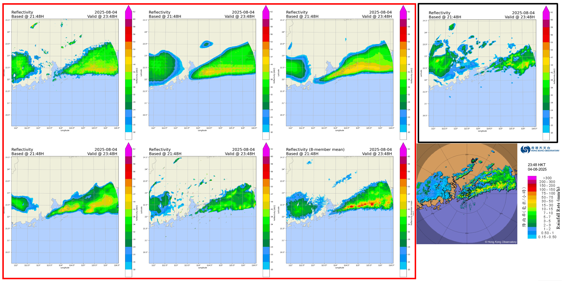
After the first deep-learning rainfall nowcasting model was put into operation, the Observatory’s nowcasting team did not stop, but continued to collaborate with academic institutions in developing more advanced AI precipitation nowcasting algorithms. At the same time, the team also made reference to deep-learning models published by the academic community, retrained the models using the Observatory’s radar data, fine-tuned and tested the algorithms. At present, several AI rainfall nowcasting models have already been implemented into operational use at the Observatory (Figure 1), supporting weather forecasting and warning services.
HKO has been continuously leading the development of nowcasting technology in the meteorological community. In 2018, the World Meteorological Organization designated the Observatory as the "Regional Specialized Meteorological Centre for Nowcasting" (RSMC for Nowcasting) to provide training and technical support on nowcasting to Southeast Asian countries. Becoming one of only three RSMCs for Nowcasting globally is an international recognition of HKO's expertise in nowcasting technology.
To improve the understanding of the evolution of heavy rain and severe convective systems over a broader area, and thereby improve the lead time and accuracy of nowcast, the Observatory has also extended the application of AI to geostationary satellite data. Based on the same concept as radar nowcasting, by analyzing satellite images updated every ten minutes, the movement of cloud bands and strong convective systems over a larger area can be tracked to compute their position and changes for the next few hours. However, the data currently provided by geostationary satellites only reflect conditions at the top layer of cloud clusters, such as solar reflectance from satellite visible channel images and cloud-top temperature observed from infrared channel observations. Therefore, it cannot directly measure the rainfall brought by the cloud cluster systems. The occurrence of convective cloud clusters and precipitation development depend on many factors, including the structure of the entire cloud cluster. Moreover, the coverage, movement, and evolution of convective cloud clusters differ significantly from actual rainfall condition on ground in terms of location, intensity, and time. The evolution of convective clouds was often not found to have any necessary correlation with the actual rainfall on ground.
To address the aforementioned technological limitations, the Observatory developed another machine-learning algorithm that makes use of historical satellite imagery and weather radar reflectivity data. By integrating image data from multiple visible and infrared satellite observation channels, the “satellite derived radar reflectivity” data can be obtained. This helps to obtain information from satellite images that more closely resemble weather radars observations, including intensity of convection and the amount of rainfall. In areas without radar observations, such as oceans, the "satellite derived radar reflectivity" provides more practical information than simply satellite images alone, enabling effective monitoring of the development of strong convective systems and rainstorms.
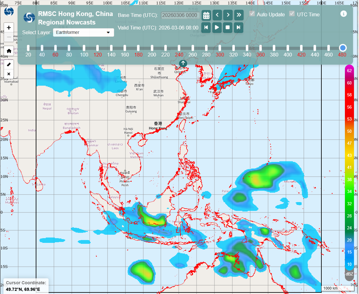
Building on this work, the Observatory further used satellite image-derived radar reflectivity data as training targets in developing two AI satellite nowcasting models, based respectively on the ResConvLSTM-GAN and Earthformer algorithms. At the end of 2025, HKO launched the aforementioned two satellite-based AI model forecast products on the RSMC for Nowcasting website (Figure 2), marking the world's first AI nowcasting products for severe convective weather up to 8 hours in advance, provided to meteorological and hydrological services in the Asia-Pacific region.
In recent years, many universities and research teams worldwide have published new deep-learning nowcasting models, showcasing a rich variety of innovations. However, their performance also varies as different AI models utilize different observational datasets and model designs. Among them there are many models based on satellite imagery that provide regional or even global rainfall nowcasts for the next few hours. As discussed above, although AI forecasting models based on satellite imagery offer wider coverage, the cloud-top temperatures measured by meteorological satellites do not necessarily have a direct relationship with actual rainfall at the ground. In addition, the spatial resolution of satellite imagery is lower than that of weather radar. Therefore, AI forecasting models based on satellite imagery still have limitations in capturing mesoscale and smaller-scale weather systems such as severe convection and rainstorms. Furthermore, given Hong Kong’s small geographical size and complex terrain, rainfall can vary significantly across different areas within a short period of time, and the development of rainstorms and severe convective systems is highly stochastic in nature. Artificial intelligence models that are trained solely on meteorological satellite imageries still face significant technical limitations in forecasting rainstorm. Therefore, not only the AI models trained by using data on cloud-top layer cannot forecast rainfall directly, there is still a long way to go before they can provide early warnings for severe convective weather.
From pioneering the meteorological community’s first deep-learning rainfall nowcasting model to launching the first batch of AI nowcasting products for use by meteorological and hydrological services in Southeast Asia in 2025, the Hong Kong Observatory has now completed the first decade of its application of AI in nowcasting. The Hong Kong Observatory will continue to pursue innovation and is committed to enhancing the quality of weather services. Although the application of AI in weather forecasting still faces challenges, it has already demonstrated certain advantages in computational speed, big-data processing and forecast accuracy. As the technology continues to mature and new forms of observational data are brought into use, the Observatory will continue to develop and apply AI technologies, while conducting detailed testing and verification, with a view to improving rainstorm forecasting, enhancing public warning services, and more effectively supporting weather forecasters in understanding the evolution and intensity change in heavy rain, thereby strengthening public communication. It is envisaged that AI will play an increasingly important role in meteorological forecasting in the years ahead, delivering more accurate and more timely weather services for the public, the aviation sector and the international community.