M7.8 Major Earthquake off the southern coast of Mindanao, the Philippines on 8 June 2026
8 June 2026
Nathan YC Wong, David TW Hui
According to the analysis by the Hong Kong Observatory, a major earthquake of magnitude 7.8 occurred off the southern coast of Mindanao, the Philippines at 7:37 a.m. Hong Kong Time on 8 June 2026. It was a shallow earthquake with a focal depth of around 10 km. The epicentre was located approximately 160 kilometres south-southwest of Davao, about 2,190 kilometres away from Hong Kong. As the epicenter is far from Hong Kong, there was no locally felt tremor. However, the seismic waveform detected by the seismograph station at Po Shan, Hong Kong showed the arrival of the P-wave at around 23:42 UTC, 7 June (7:42 a.m., 8 June Hong Kong Time), approximately 5 minutes after the origin time. Besides, there were also subsequent aftershocks of magnitude 6 or above around this epicentre.
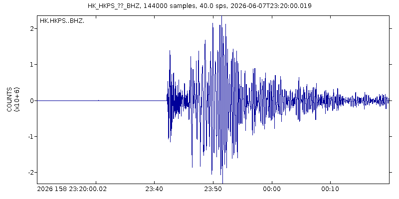
Figure 1: The seismic waves associated with the major earthquake with magnitude 7.8 off the southern coast of Mindanao, the Philippines recorded at Po Shan station, Hong Kong on 8 June 2026 Hong Kong Time.
The tsunami triggered by this major earthquake is mainly regional. In the Philippines, tsunami waves of 1.48 metres and 0.84 metres were recorded along the coast of the Sarangani Province and Sultan Kudarat Province respectively; tsunami waves of 0.25 metres and 0.21 metres were also recorded at Zamboanga, and Mati in Davao Oriental Province on the morning of 8 June 2026 [1]. In Indonesia, tsunami waves of nearly 1 metre were recorded at Talengen Tourism Pier in North Sulawesi Province, whereas tsunami waves of 0.20 metres and 0.10 metres were recorded at Port of Kema Fishing and Bitung respectively [2]. Besides, the Pacific coast of Japan also recorded tsunami waves up to 0.3 metres near 4 p.m. Hong Kong Time. According to the calculation of the Hong Kong Observatory’s tsunami model (Figure 2), as the tsunami waves spread outwards, the northwestward and southward propagating tsunami waves were largely obstructed by the Philippine archipelago and the islands surrounding the Sulawesi Sea, such that those departing from the region weakened by a large extent and the tsunami height became significantly lower. As the amplitude of tsunami waves reaching the South China coast, including Hong Kong, was too small, no tsunami waves could be detected in this area.
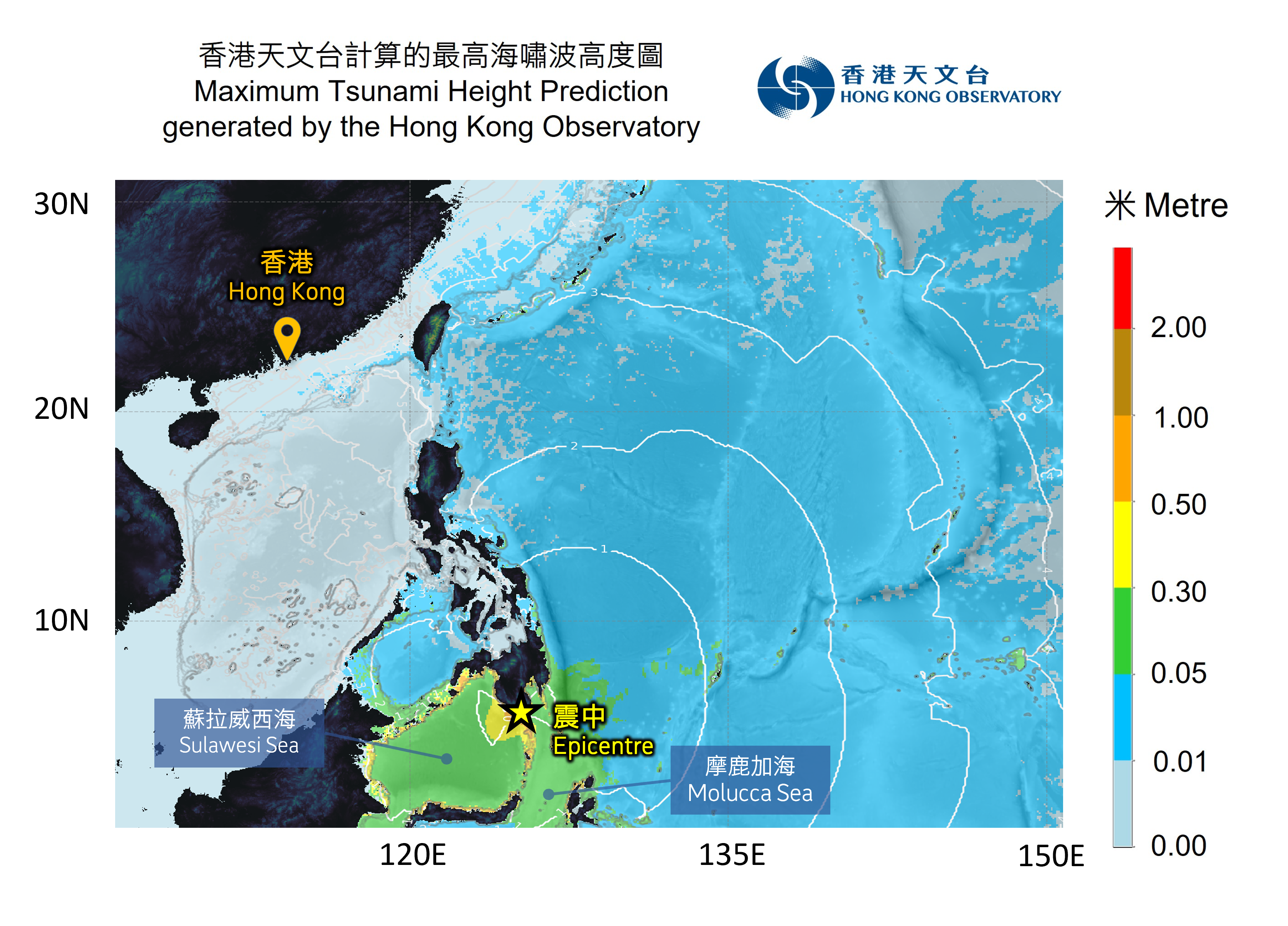
Figure 2: Tsunami wave heights (shown in colour) and travel times (white lines at hourly intervals) calculated by the Hong Kong Observatory.
This major earthquake occurred near the southern coast of Mindanao Island in the Philippines, located at the convergent boundary between the Sunda Plate and the Philippine Sea Plate (Figure 3). It is an integral part of the Pacific Ring of Fire, where seismic activity is frequent. This major earthquake was a reverse faulting event (Figure 4) occurring at a shallow depth under the sea. This released elastic energy from the crust triggered seawater oscillations, forming a tsunami that primarily affected coastal areas near the region. From 1900 to the present, 64 major earthquakes of magnitude 7.0 or above have occurred within a 500-kilometer radius of this major earthquake [3], with the most recent one being a magnitude 7.3 earthquake on 10 October 2025.

Figure 3: A map showing the tectonic plates and the location of this earthquake and the historical earthquakes in the region.
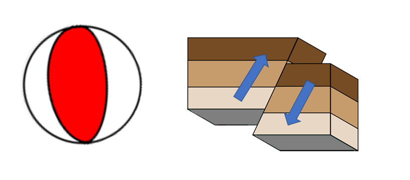
Figure 4: Focal mechanism of this earthquake (left) and the corresponding fault motion (right)
The Hong Kong Observatory continuously monitors the water level data from tide stations and tsunami buoys across the western Pacific and the South China Sea. The sea level observations from the UNESCO Intergovernmental Oceanographic Commission’s webpage for Sea Level Station Monitoring Facility showed the water level changes at Davao in the southern Philippines (Figure 5), where a maximum tsunami height of approximately 0.46 metres was recorded on the morning of 8 June, Hong Kong Time.
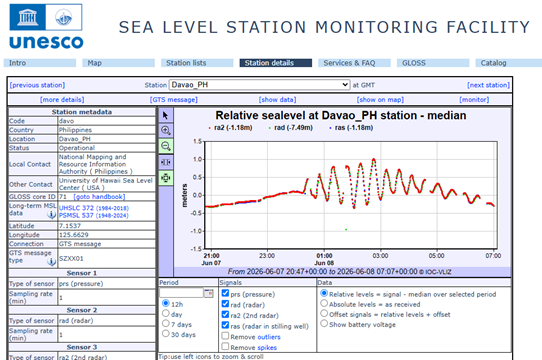
Figure 5: Water level observations at Davao in the southern Philippines, as shown on the UNESCO Intergovernmental Oceanographic Commission’s webpage for Sea Level Station Monitoring Facility [2].
References:
[1] Philippine Institute of Volcanology and Seismology's Announcement Regarding This Earthquake and Tsunami
[2] The Intergovernmental Oceanographic Commission of UNESCO (UNESCO-IOC) "Sea level station monitoring facility" website
[3] United States Geological Survey (USGS): Earthquake Catalog