To Know More About Positioning Technology
To Know More About Positioning Technology
TAM Hiu-ching, Hong Kong Observatory
Geodetic Survey Section, Survey and Mapping Office, Lands Department
Geodetic Survey Section, Survey and Mapping Office, Lands Department
December 2025
It’s lunchtime now and when one is just wondering where to dine, the mobile phone buzzes with a notification. Is the AI assistant suggesting a restaurant? No, the notification comes from the “MyObservatory” mobile application, saying that “Rain and lightning is around your current location”. With that information, it was decided to dine at a restaurant in the mall nearby instead of venturing farther away. This convenient feature is powered by the automatic positioning technology of the phone. By granting “MyObservatory” access to device’s location, the app can automatically display the location-specific weather information, including real-time observations, automatic forecasts and push notifications for rain and lightning information based on one’s location.
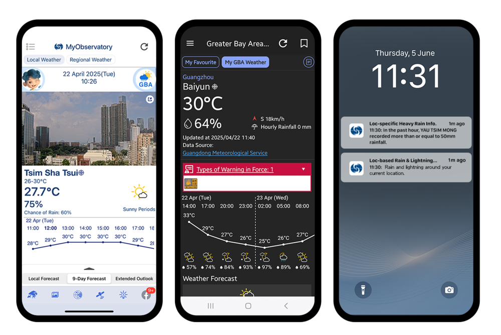
Figure 1 Personalised location-specific weather service of “MyObservatory” provides weather information near the users’ locations on its homepage (left) and "Greater Bay Area Weather" page (middle). User can also opt for push notifications about the rain and lightning information from “Location-based Rain & Lightning Forecast” and “Location-specific Heavy Rain Information” based on their locations (right).
Automatic positioning function enables the “MyObservatory” to provide personalised location-specific weather services. Most mobile devices nowadays are equipped with satellite positioning capabilities, primarily through the “Global Navigation Satellite System” (GNSS) to accurately calculate the position. GNSS not just includes the United States's Global Positioning System (GPS), but also encompasses China's “BeiDou”, the European Union's “Galileo” and Russia's “Global Navigation Satellite System” (GLONASS), etc. All such systems consist of multiple satellites, ground control stations, and monitoring stations. Each satellite, equipped with precise atomic clocks, orbits Earth and continuously transmits signals. The signals contain ephemeris data[1], such as satellite’s real-time position and operational status, as well as other information like precise timing, which are essential for calculating distances and determining locations. The positioning principle of GNSS is based on “trilateration”, which involves determining the position of GNSS receiver by calculating the distance between each satellite and the receiver using the transmission time of the received signals and geometric mathematical models (Figure 2)[2-3].
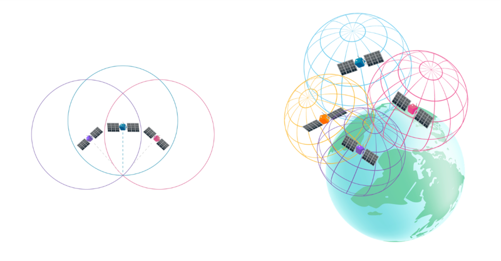
Figure 2 Simply speaking, if three satellites are positioned on the same two-dimensional plane, the intersection point of the circles centred at each satellite’s location with radii equal to their respective distances to the GNSS receiver would mark the receiver’s position (left). In real-world’s three-dimensional space, data from at least four satellites are required to determine receiver’s longitude, latitude and altitude by calculating the intersection point of the corresponding spherical surfaces (right).
However, this method requires transmitting and processing a large amount of raw data (including satellite ephemeris etc.) during initial positioning, which typically results in a longer time for mobile devices to calculate their initial positions. This process indeed can be improved with the help of “Assisted Global Navigation Satellite System” (A-GNSS) services. A-GNSS leverages public mobile networks to quickly deliver satellite ephemeris data to a mobile device, reducing transmission time and significantly speeding up positioning acquisition.
Nonetheless, the GNSS positioning accuracy may deteriorate due to degradation of GNSS signals by various factors such as signal blockage or reflection by nearby high-rise buildings or mountains, or signal interference. In addition, strong solar activity may disrupt Earth’s ionosphere, interfering with GNSS signal transmission and reducing positioning accuracy[4-5]. As a mobile device is continuously receiving mobile network signals from the nearby mobile base stations, these signals can be used to improve the positioning accuracy. Moreover, mobile devices nowadays can also utilise other technologies like scanning nearby radio signal sources, including Wi-Fi access points and Bluetooth devices, to assist in location determination.
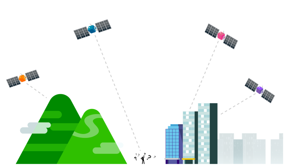
Figure 3 The transmission of the GNSS signals can be degraded due to various factors such as signal blockage or reflection by nearby high-rise buildings or mountains, or signal interference, resulting in reduced positioning accuracy.
GNSS has wide applications in Hong Kong, not only for mobile device positioning but also in mapping, land boundary surveying, civil engineering, infrastructure development, navigation, rescue and searching, etc. To further enhance the application and development of GNSS in Hong Kong, the Lands Department continues to allocate resources to develop and maintain the “Hong Kong Satellite Positioning Reference Station Network” (SatRef)[6]. This network consists of 16 Continuously Operating Reference Stations and 3 Integrity Monitoring stations, covering the entire territory and receiving GNSS signals round-the-clock. The received data are systematically processed and analysed to provide data products and high-precision positioning services to users at no cost. Among these, the Network Real-Time Kinematic (Network RTK)[7] service further enables users to achieve real-time centimetre-level positioning accuracy under specific conditions with compatible equipment.
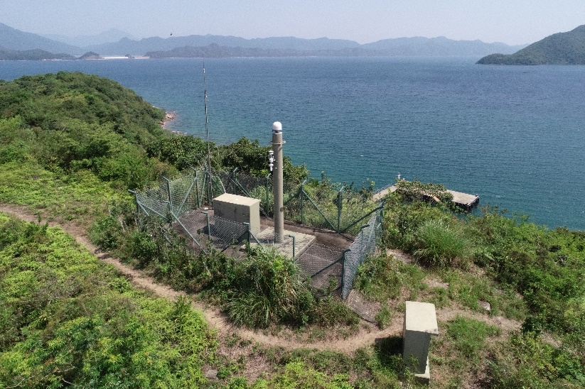
Figure 4 A SatRef Continuous Operating Reference Station in Shap Sze Heung.
As for GNSS, it also has many applications in the operations of the Observatory. Besides providing location-specific weather services in MyObservatory, it is also used in the applications such as the automatic upper-air sounding system[8] for the upper-air meteorological observations, and dropsonde system[9] operated in collaboration with the Government Flying Service to collect more real-time meteorological measurements on tropical cyclones which are valuable for analysing the location and structure of the storms (Figure 5). The development of positioning technology has brought great convenience to our lives. Whether in daily life or professional fields, positioning technology will continue to drive social progress and development, making our lives more convenient and secure.
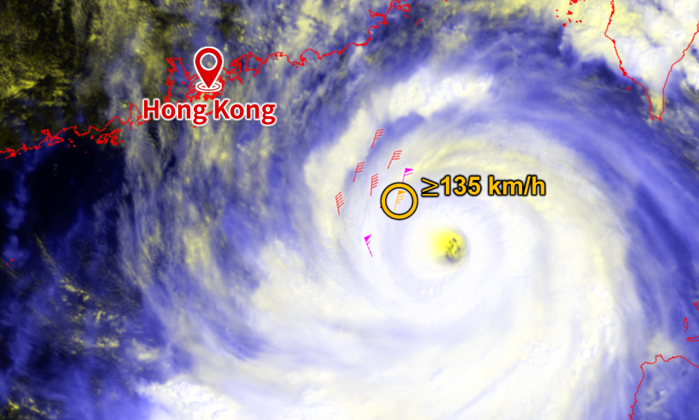
Figure 5 Winds up to around 135 km/h near the sea surface about 120 km to the centre of Super Typhoon Ragasa were captured by the dropsonde system in the morning on 23 September 2025[10].
References:
[1] Bhatta, B. (2021). Almanac and ephemeris. In Global navigation satellite systems: New technologies and applications (pp. 43). CRC Press.
[2] Kaplan, E. D., & Hegarty, C. J. (2006). Understanding GPS: principles and applications Second Edition. Artech house, 14-16.
[3] Teunissen, P. J., & Montenbruck, O. (Eds.). (2017). Springer handbook of global navigation satellite systems (Vol. 10, pp. 978-3). Cham, Switzerland: Springer International Publishing.
[4] Weather Note:太空天氣會影響日常生活嗎?(Chinese only)
[5] Real-time Ionospheric Scintillation Monitoring, Hong Kong Observatory.
[6] Hong Kong Satellite Positioning Reference Station Network, Geodetic Survey Section, Lands Department.
[7] Network Real Time Kinematic (RTK) Service, Geodetic Survey Section, Lands Department.
[8] Upper-Air Weather Measurements in Hong Kong.
[9] 追風?下投探空。(Chinese only)
[10] Weather Note:樺加沙帶來的十號風球。(Chinese only)