Overview of Tropical Cyclone in October 2025
|
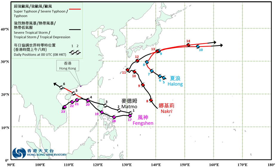
Four tropical cyclones occurred over the western North Pacific and the South China Sea in October 2025. Among them, Matmo (2521) and Fengshen (2524) necessitated the issuance of the tropical cyclone warning signal by the Observatory. Matmo (2521) formed as a tropical depression over the western North Pacific about 1 110 km east of Manila on the morning of 1 October, and moved west-northwestwards approaching Luzon. It moved across Luzon on 3 October, and entered the central part of the South China Sea that night. It then continued to move steadily west-northwestwards across the northern part of the South China Sea towards Leizhou Peninsula. Matmo intensified into a typhoon on the night of 4 October, and attained its peak intensity with an estimated maximum sustained wind of 145 km/h near its centre over the seas east of Hainan Island in the small hours of the next day. It made landfall successively over Zhanjiang of Guangdong and Fangchenggang of Guangxi, from the afternoon of 5 October to the small hours of the next day, then moved inland and weakened rapidly. Matmo finally degenerated into an area of low pressure in the northern part of Vietnam in the small hours of 7 October. According to press reports, during the passage of Matmo over the Philippines, over 340 000 people were affected and more than 80 houses were damaged. Economic loss exceeded PHP 100 million. Matmo and its remnant brought torrential rain and squalls to Hainan, Guangdong, Guangxi and Yunnan. More than 3.5 million people were affected and more than 280 000 people were evacuated. Over 11 000 houses were damaged, more than 110 000 hectares of crops were damaged, and economic loss exceeded RMB 15 billion. Accumulated rainfall in Zhanjiang of Guangdong and Fangchenggang of Guangxi reached 454 millimetres. Matmo also brought squalls to Macau, causing one injury and 16 incident reports. Matmo and its remnant brought torrential rain to the northern part of Vietnam, causing widespread flooding. Accumulated rainfall in Thai Nguyen reached 350 millimetres. In Vietnam, there were 18 deaths or missing, and 15 injuries. More than 230 000 houses were damaged, more than 30 000 hectares of crops were damaged, and economic loss exceeded VND 19.5 trillion. For detailed information of Matmo including its impact to Hong Kong, please refer to the Tropical Cyclone Report of Matmo. Halong (2522) formed as a tropical depression over the western North Pacific about 230 km east of Iwo Jima on the night of 4 October, and moved generally west-northwestwards across the vicinity of Iwo Jima in the following two days. It intensified into a typhoon in the small hours of 7 October, and gradually turned to track northwestwards to northwards. Halong intensified rapidly into a super typhoon and attained its peak intensity in the small hours of 8 October, with an estimated maximum sustained wind of 185 km/h near its centre. It gradually turned to move eastwards across the seas south of Honshu, Japan that day and the next day, and weakened gradually. Halong weakened into a severe tropical storm on the afternoon of 10 October, and finally evolved into an extratropical cyclone over the western North Pacific east of Japan that night. According to press reports, Halong brought torrential rain and squalls to the vicinity of the Izu Islands of Japan, with a record-breaking 12-hour rainfall of 349 millimetres recorded over Hachijojima Island. In Kanagawa Prefecture of Japan, three people were swept away by waves, with one dead and two rescued. The extratropical cyclone evolved from Halong moved from the western North Pacific to the eastern North Pacific, bringing hurricane-force winds and record-breaking water levels to the Alaskan West Coast of the United States of America from 11 to 13 October local time. Water levels in parts of the Yukon–Kuskokwim Delta were 1.8 to 1.9 m above normal. During the passage of the extratropical cyclone over the Alaskan West Coast, there were at least one death, two missing and more than 1 900 people evacuated. Over 800 houses were damaged, and economic loss was estimated at approximately USD 125 million. Nakri (2523) formed as a tropical depression over the western North Pacific about 510 km west-northwest of Guam on the night of 7 October, and tracked northwestwards to north-northwestwards in the following two days. It turned to move westwards towards the vicinity of the Ryukyu Islands on 10 October, and turned again to track northeastwards across the seas south of Kyushu, Japan that next day. Nakri turned gradually to track east-northeastwards across the seas south of Shikoku and Honshu, Japan on 12 October, and intensified into a typhoon in the small hours of the next day, attaining its peak intensity with an estimated maximum sustained wind of 120 km/h near its centre. It weakened into a severe tropical storm on the night of 14 October, and finally evolved into an extratropical cyclone over the western North Pacific east of Japan in the small hours of the next day. According to press reports, Halong and Nakri successively affected the vicinity of the Izu Islands of Japan within five days. Approximately 340 people were evacuated, and over 200 houses were damaged. Water and electricity supplies to about 2 700 and 2 200 households were disrupted respectively. Fengshen (2524) formed as a tropical depression over the western North Pacific about 1 100 km east of Manila on the morning of 17 October and moved generally westwards, approaching the central part of the Philippines. It gradually turned to track northwestwards across the Philippines and entered the central part of the South China Sea in the following two days. Fengshen entered the northern part of the South China Sea and intensified into a severe tropical storm on 20 October. It gradually turned southwestwards the next day and attained its peak intensity that night, with an estimated maximum sustained wind of 110 km/h near its centre. It then weakened progressively, and finally degenerated into an area of low pressure over the coastal areas of the central part of Vietnam on the evening of 23 October. According to press reports, Fengshen brought torrential rain and squalls to the Philippines, with a 24-hour rainfall of 400.7 millimetres recorded over Guiuan in Eastern Samar. Fengshen caused seven deaths, two missing persons and one injury in the Philippines. Over 490 000 people were affected and more than 5 800 houses were damaged. Economic loss exceeded PHP 11 million. For detailed information of Fengshen including its impact to Hong Kong, please refer to the Tropical Cyclone Report of Fengshen. |
Provisional Tropical Cyclone Tracks in October 2025