Deployment of Drifting Buoys by the Hong Kong Observatory in 2022
The ocean covers about 70% of the Earth’s surface and has great impact to the global weather. Ocean observations are essential for weather analysis and forecasting. In early years, observations over the ocean were rather sparse. With the advancement of technologies in recent years, different kinds of observational instruments and techniques have been used to observe and study the ocean. One of the devices being commonly used in ocean observation is drifting buoy, or simply call a drifter (Figure 1). Drifting buoys are easy-to-deploy and can reliably measure the atmosphere and ocean surface conditions. The lifetimes of buoys can be of the order of a year or so, but in general it lasts for only a few months on average due to vandalism, running aground, battery problem and etc.
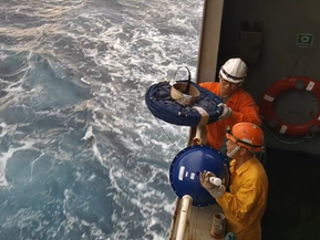
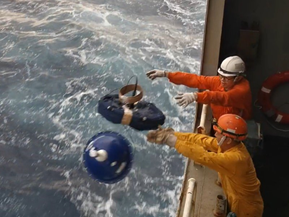
Figure 1. Drifting buoy deployed by the crews of HKVOS.
In June 2015, the Observatory collaborated with the Orient Overseas Container Line Limited (OOCL) to conduct a trial study to enhance meteorological observations over the South China Sea with the assistance of ocean-going vessels. A Hong Kong Voluntary Observing Ship (HKVOS) was engaged to deploy a drifting buoy in the South China Sea at that time. This first deployed drifter was carried along by ocean currents to make in-situ pressure and sea surface temperature measurements. The data was transmitted to the Observatory every hour via satellite for dissemination on the GTS. The gathering of more meteorological data supports weather monitoring over the South China Sea and surrounding areas, enhancing the capacity of forecasting tropical cyclones including their formation and changes in intensity, thus contributing to navigation safety in the region.
The Observatory continued to deploy drifting buoys in the South China Sea and western North Pacific in the following years under the Barometer Upgrade Program of the Data Buoy Cooperation Panel (DBCP). DBCP is an international program under the World Meteorological Organization (WMO) and the Intergovernmental Oceanographic Commission (IOC) of UNESCO, and was founded to maintain the network of over thousands of drifting buoys operated by national weather services around the world. It coordinates the use of data buoys to observe atmospheric and oceanographic conditions, and aims to increase the quantity, quality, global coverage and timeliness of atmospheric and oceanographic data.
In 2021, the Observatory deployed three drifting buoys in the South China Sea and two others in the western North Pacific with the assistance of two HKVOS. The buoys drifted across wide areas of the South China Sea and seas East of Luzon (Figure 2), and collected valuable information during the passage of several tropical cyclones within the region (Figures 3-8).
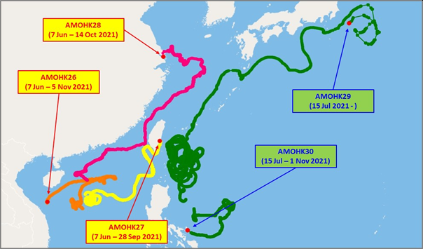
Figure 2. Track of the five drifting buoys deployed in 2021. The red dots denote their last reported position.
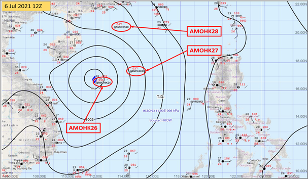
Figure 3. A tropical depression captured by “AMOHK26”, “AMOHK27” and “AMOHK28” over the South China Sea at 12 UTC on 6 July 2021.
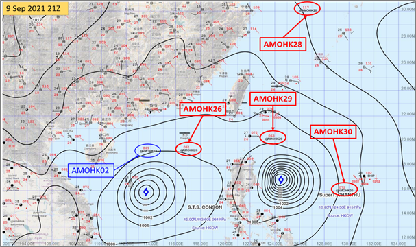
Figure 4. Severe Tropical Storm Conson (2113) captured by “AMOHK26” over the South China Sea and Super Typhoon Chanthu (2114) captured by “AMOHK29” and “AMOHK30” over the western North Pacific at 21 UTC on 9 September 2021. Buoy “AMOHK28” was still in operation over the East China Sea, while another modified drifter “AMOHK02” onboard one Hong Kong voluntary observing ship was located to the north of Conson at that time.
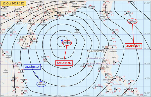
Figure 5. Close encounter of “AMOHK26” with Severe Tropical Storm Kompasu (2118) over the South China Sea at 18 UTC on 12 October 2021.
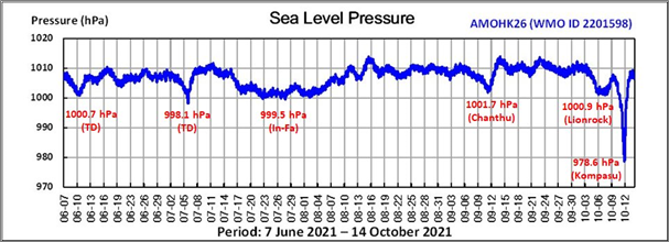
Figure 6. Time series of pressure measurements by “AMOHK26” capturing the low pressures associated with a number of tropical cyclones over the South China Sea and recording the lowest pressure of 978.6 hPa near the centre of Severe Tropical Storm Kompasu (2118) on 12 October 2021.
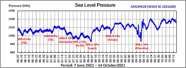
Figure 7. Time series of pressure measurements by “AMOHK28” capturing the low pressures of a number of tropical cyclones over the South China Sea and the East China a between June and October 2021.
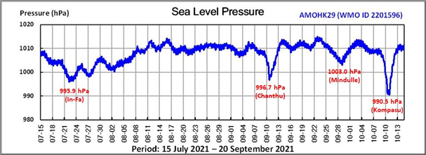
Figure 8. Time series of pressure measurements by “AMOHK29” capturing the low pressures within the circulation of several tropical cyclones over the western North Pacific between June and October 2021.
In 2022, two drifting buoys were deployed in the South China Sea in early July with the assistance of HKVOS (Figure 9). They have also been making useful observations during the passage of three tropical cyclones, namely Tropical Storm Mulan (2207), Severe Tropical Storm Ma-On (2209) and Super Typhoon Noru (2216), which traversed the South China Sea in August and September (Figures 10, 11 and 12). Both drifting buoys were within the circulation of the storms and captured the associated low pressures (Figures 13 and 14). The two drifters are expected to continue contributing valuable observations during the tropical cyclone season.
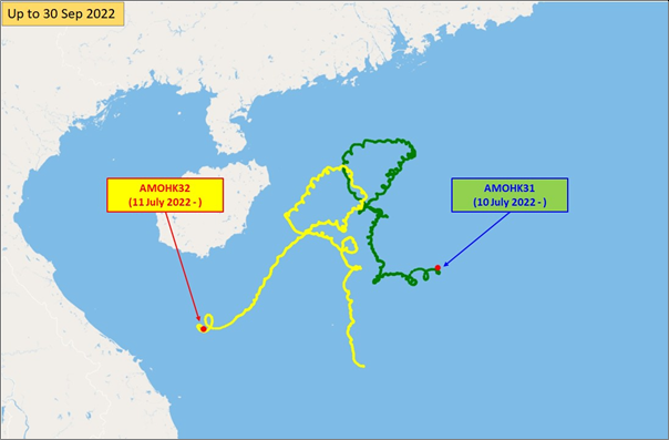
Figure 9. Track of the two drifting buoys deployed over the South China Sea in July 2022. The red dots denote their latest reported position.
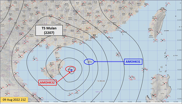
Figure 10. Close encounter of “AMOHK32” with Tropical Storm Mulan (2207) over the South China Sea with “AMOHK31” within the circulation of the storm at 21 UTC on 9 August 2022.
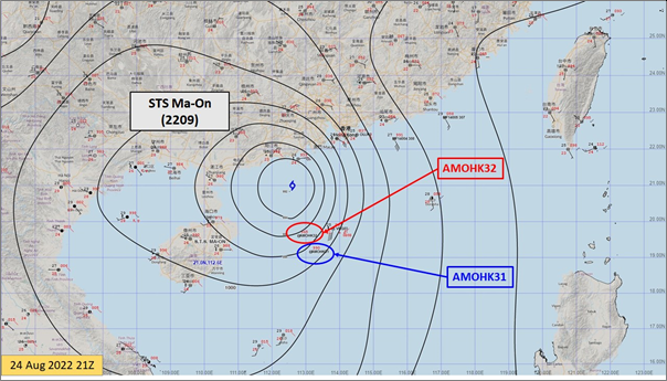
Figure 11. Severe Tropical Storm Ma-On (2209) captured by both “AMOHK31” and “AMOHK32” over the South China Sea at 21 UTC on 24 August 2022.
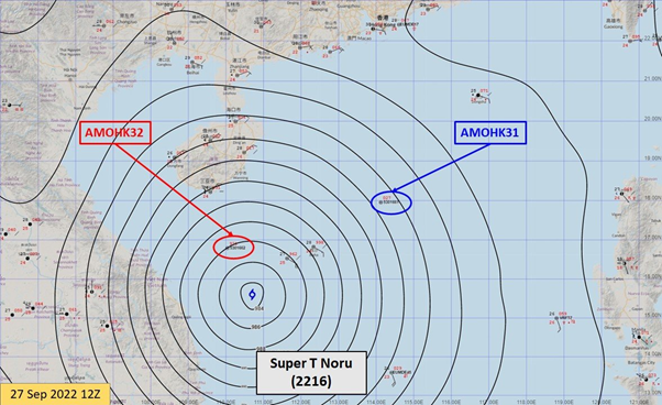
Figure 12. Super Typhoon Noru (2216) captured by both “AMOHK31” and “AMOHK32” over the South China Sea at 12 UTC on 27 September 2022.
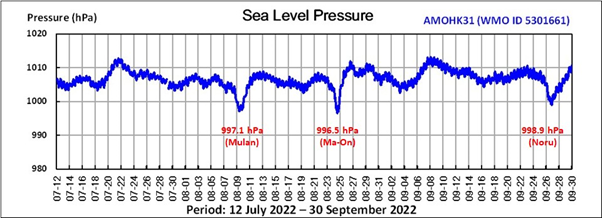
Figure 13. Time series of pressure measurements by “AMOHK31” capturing the low pressures of Mulan (2207), Ma-On (2209) in August 2022 and Noru (2216) in September 2022, and recording the lowest pressure of 996.5 hPa associated with Ma-On (2209) on 24 August 2022.
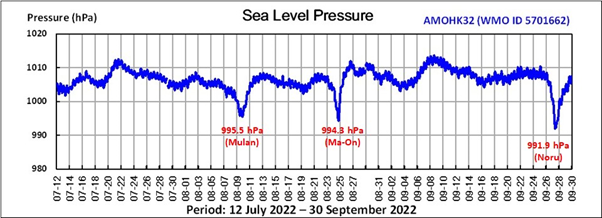
Figure 14. Similar to Figure 12 but by “AMOHK32”, recording the lowest pressure of 991.9 hPa associated with Noru (2216) on 27 September 2022.
Chow Chi Kin