Skip Content
Report on Super Typhoon Ragasa (2518)
Report on Super Typhoon Ragasa (2518)
Figures
Figure 1a: Provisional track of Ragasa (2518): 18 – 25 September 2025
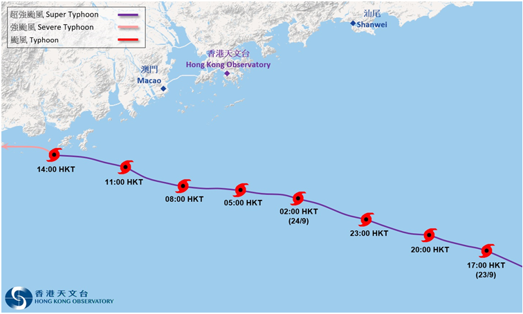
Figure 1b: Provisional track of Ragasa (2518) near Hong Kong
Figure 2a: Time series of the estimated maximum sustained wind speed near the centre of Ragasa (2518): 18 – 25 September 2025 (initial assessment)
Figure 2b: Time series of the estimated minimum sea level pressure of Ragasa (2518): 18 – 25 September 2025 (initial assessment)
Figure 3: Rainfall distribution on 22 – 25 September 2025
Figure 4a: Infra-red satellite imagery at around 2 a.m. on 22 September 2025
Figure 4b: Infra-red satellite imagery at around 10:30 p.m. on 22 September 2025
Figure 4c: Infra-red satellite imagery at around 2:20 p.m. on 23 September 2025
Figure 5: The Government Flying Service (GFS) dispatched a fixed-wing aircraft on 23 September to conduct surveillance near the centre of Ragasa
Figure 6a: Image of radar echoes captured at 10:12 p.m. on 23 September 2025
Figure 6b: Image of radar echoes captured at 7:12 a.m. on 24 September 2025
Figure 7a: 10-minute mean wind direction and speed recorded at various stations in Hong Kong at 6:22 a.m. on 24 September 2025
Figure 7b: 10-minute mean wind direction and speed recorded at various stations in Hong Kong at 7:09 a.m. on 24 September 2025
Figure 7c: 10-minute mean wind direction and speed recorded at various stations in Hong Kong at 10:32 a.m. on 24 September 2025
Figure 8: Traces of 10-minute mean wind speed recorded at Cheung Chau, Waglan Island and Ngong Ping on 23 – 25 September 2025
Figure 9: Traces of mean sea-level pressure recorded at the Hong Kong Observatory, Cheung Chau and Waglan Island on 23 – 25 September 2025
Figure 10: Maximum sea level recorded at various tide stations in Hong Kong and flood reports on 23 – 25 September 2025
Figure 11: Traces of sea level and storm surge recorded at Quarry Bay, Tsim Bei Tsui and Tai Po Kau on 23 – 25 September 2025
Figure 12a: The passage of Ragasa resulted in fallen trees in many parts of Hong Kong
Figure 12b: During the passage of Ragasa, many roads in Hong Kong were blocked by fallen trees
Figure 13: During the passage of Ragasa, a tree of about 30 m tall collapsed in Oi Man Estate in Ho Man Tin
Figure 14: During the passage of Ragasa, a 20 m by 30 m exterior scaffolding on the top floor of a building on Waterloo Road in Ho Man Tin was damaged, requiring the closure of six nearby traffic lanes
Figure 15: During the passage of Ragasa, the wall of a primary school in Kowloon Tong collapsed
Figure 16: During the passage of Ragasa, the wall of a detached house in Kowloon Tong was damaged by a fallen tree
Figure 17: During the passage of Ragasa, the glass curtain wall of a building in Tsim Sha Tsui was damaged
Figure 18: During the passage of Ragasa, the exterior wall tiles of a residential building in Sham Tseng peeled off
Figure 19: During the passage of Ragasa, a construction site container in Tseung Kwan O was blown into the sea by high winds
Figure 20: Under the influence of the storm surge induced by Ragasa, the water level in Tai O rose significantly, causing flooding
Figure 21: Under the influence of the storm surge induced by Ragasa, the water level at Sam Ka Tsuen in Lei Yue Mun rose significantly, causing flooding
Figure 22: Under the influence of the storm surge induced by Ragasa, the water level at Kar Wo Lei in Tuen Mun rose significantly, causing flooding
Figure 23: Under the influence of the storm surge induced by Ragasa, the water level of the Shing Mun River in Sha Tin rose significantly, causing flooding in nearby footpaths, cycle tracks and subways
Figure 24: Under the influence of the storm surge induced by Ragasa, the water level of the Lam Tsuen River in Tai Po rose significantly, causing flooding in nearby footpaths and subways
Figure 25: During the passage of Ragasa, rough waves crashed at the breakwater in Chai Wan
Figure 26: During the passage of Ragasa, rough waves crashed at the coast of Heng Fa Chuen in Chai Wan
Figure 27: During the passage of Ragasa, high waves battered Tung Wan in Cheung Chau
Figure 28: Under the influence of the overtopping waves triggered by Ragasa, seawater crashed into a hotel in Aberdeen, shattering its glass doors and flooding its lobby
Figure 29: During the passage of Ragasa, rough waves battered Tseung Kwan O South Waterfront Promenade, where a large stone was washed ashore from the breakwater
Figure 30: During the passage of Ragasa, paving blocks were damaged and cycle tracks were flooded at Tseung Kwan O South Waterfront Promenade
Figure 31: Under the influence of the overtopping waves triggered by Ragasa, seawater surged into a restaurant at Tseung Kwan O South Waterfront Promenade, shattering its glass doors and leaving scattered items on the ground
Figure 32: During the passage of Ragasa, a landslide occurred on Hospital Road in Sai Ying Pun
Figure 33: During the passage of Ragasa, a landslide occurred on Wong Ma Kok Road in Stanley
Figure 34: During the passage of Ragasa, a landslide occurred on Bride's Pool Road in Tai Po
Figure 35: Affected by the heavy rain brought by Ragasa, a sunflower field in Yuen Long was flooded
Figure 36: During the passage of Ragasa, several vessels collided with the shore railings off the coast of Laguna Verde in Hung Hom and Hoi Sham Park in To Kwa Wan
Figure 37: During the passage of Ragasa, mariculture rafts and facilities at Cheung Sha Wan in Lantau Island were damaged by the wind and waves
Tables
Table 1: Maximum gust peak speeds and maximum hourly mean winds with associated wind directions recorded at various stations when the tropical cyclone warning signals for Ragasa were in force
Table 2: Maximum 60-minute mean wind speeds and maximum gusts recorded during the passage of Ragasa and the tropical cyclones necessitating the issuance of No. 10 signals recently (Hato in 2017, Mangkhut in 2018, Saola in 2023 and Wipha in 2025)
Table 3: Periods during which sustained strong and gale force winds were attained at the eight reference anemometers in the tropical cyclone warning system when tropical cyclone warning signals for Ragasa were in force
Table 4: Daily rainfall amounts recorded at the Hong Kong Observatory Headquarters and other stations during the passage of Ragasa
Table 5: Times and heights of the maximum sea level and the maximum storm surge recorded at tide stations in Hong Kong during the passage of Ragasa