Earthquake Risk of Japan's Nankai Trough and its Potential Impact to Hong Kong
14 February 2025
CHAN Yuk-po Bowie, WONG Cheuk-yiu Lillian
Recently, earthquake and tsunami experts from official agencies in Japan have repeatedly raised alarms regarding the potential earthquake risks along the Nankai Trough. They alerted that the Pacific coast of Japan stretching from Kanto to Kyushu could face tsunamis exceeding 10 m in the event of a great earthquake. This has prompted reminders for the public to prepare for earthquakes along the Nankai Trough which could occur at any time. Given that great earthquakes can trigger tsunamis capable of traversing oceans, this piece of information has garnered widespread international attention. In this blog, the geological features and seismic activity of the Nankai Trough, as well as its potential impact to Hong Kong will be studied from a scientific perspective.
What is Nankai Trough? Why will earthquakes occur there?
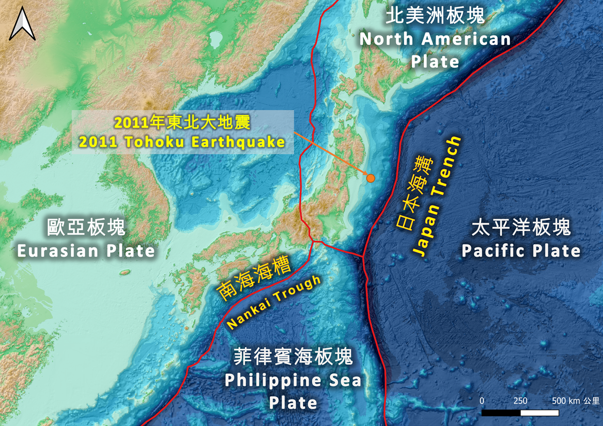
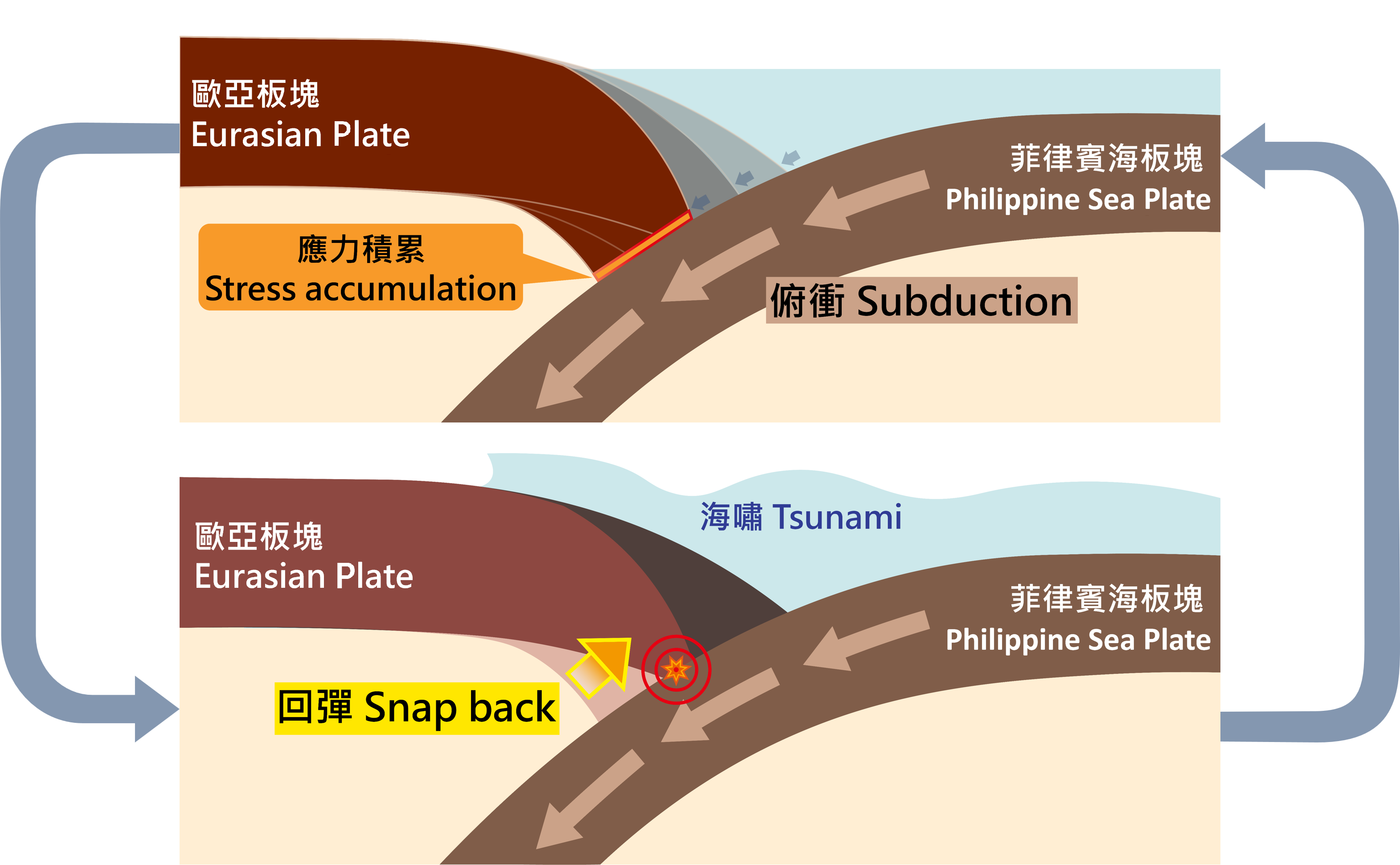
The Nankai Trough is located at the southern seas of Japan, extending approximately 700 km from Suruga Bay to Hyuga-nada. It belongs to the convergent plate boundary between the Philippine Sea Plate and the Eurasian Plate (Figure 1). The Philippine Sea Plate subducts beneath the Eurasian Plate at a rate of about 5 cm per year [1]. The uneven movement along the plate boundary results in slip deficits in the slower-moving sections. Under relative plate motion, stress accumulates on these slower-moving crusts. When the accumulated stress exceeds the friction in between the two plates, the stored energy is suddenly released, causing shaking of the crust, that is, an earthquake occurs (Figure 2). As the Philippine Sea Plate continues to subduct along the Nankai Trough, the process of stress accumulation and release repeats as a cycle, but the earthquake cycles are not entirely regular.
The Past and Future of the Nankai Trough
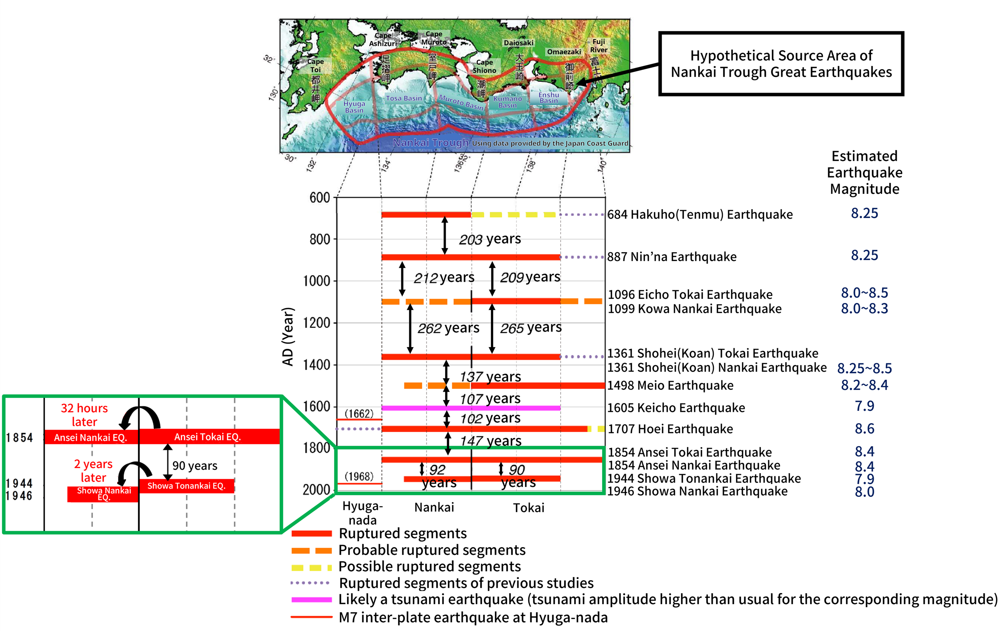
In 2013, the Japan Earthquake Research Committee (JERC), under the Headquarters for Earthquake Research Promotion of Japan, issued a long-term assessment report on the seismic activities along the Nankai Trough [2]. Historical records indicate that since the Hakuho (Tenmu) earthquake in 684, great earthquakes of magnitude 8 or above have occurred at the Nankai Trough approximately every 100 to 200 years over the past 1,400 years (Figure 3). The largest recorded earthquake was the M8.6 Hoei earthquake in 1707, which caused a massive tsunami and resulted in over 5,000 deaths [3]. Studies of tsunami sediments have revealed ancient earthquakes over the millennia, suggesting that tsunamis comparable to the Hoei earthquake may occur every 300 to 600 years. Even larger tsunami event than that triggered by the Hoei earthquake might have occurred in the past. In 2012, the Japan Committee for Modelling a Nankai Trough Megaquake published the second report [4], focusing on the maximum-level tsunamis that could be brought about by the Nankai Trough, despite their extremely low frequency. Tsunami simulations for M9.0-9.1 earthquakes were thus set up to estimate the associated potential disastrous impact for the purpose of disaster prevention.
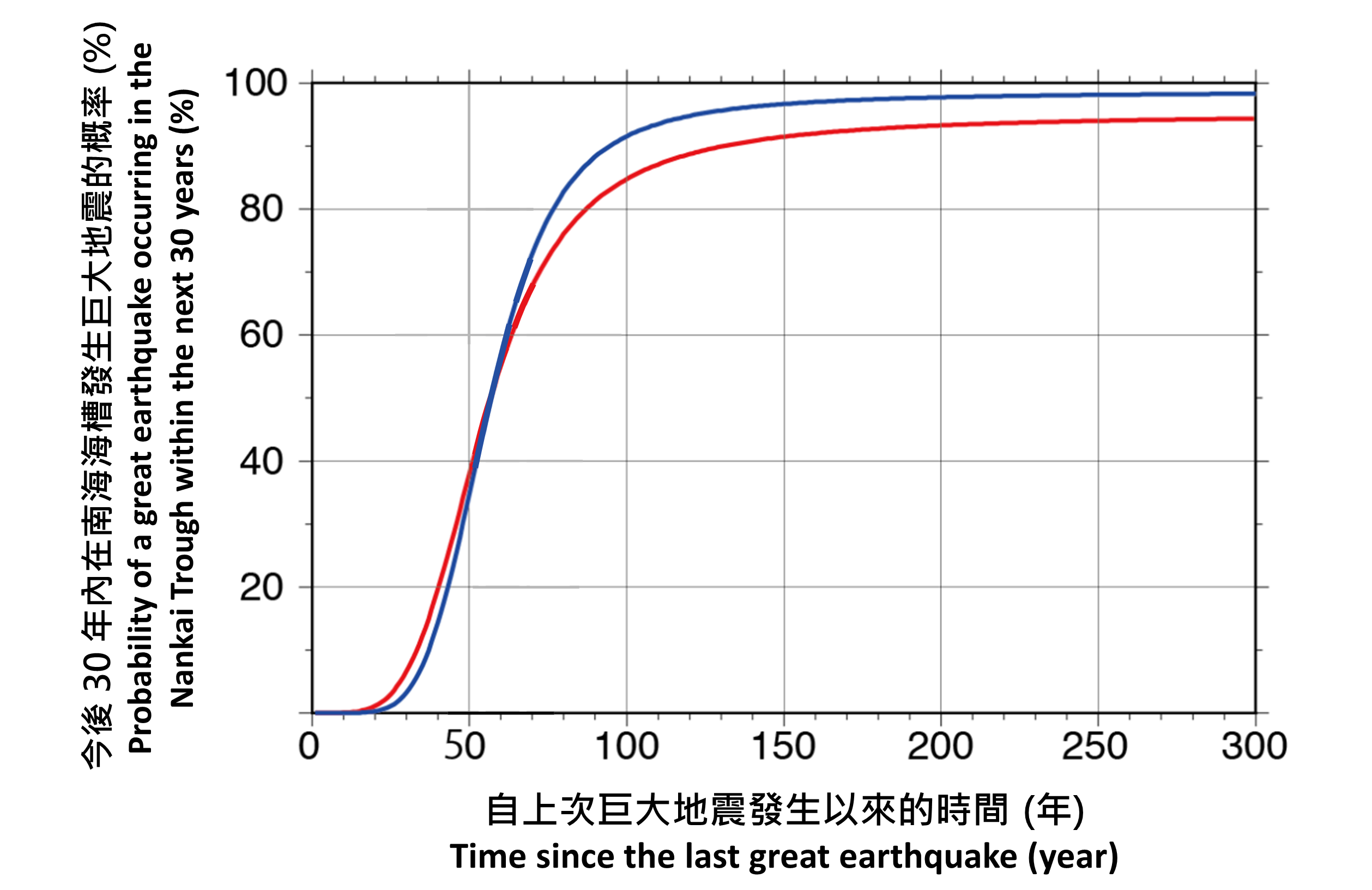
Globally, statistical data indicates that approximately 20 earthquakes of magnitude 7 or above occur each year [6], but the exact timing, location, and magnitude of these events remain unpredictable [7]. As such, earthquake agencies worldwide assess earthquake risks over different time scales and issue warning as soon as possible when earthquakes occur. Since 2004, the JERC has been updating the long-term assessment results of active fault zones and subduction zone earthquakes annually. For regions with a recent history of occurrence of three or more earthquake events, such as the Nankai Trough, historical data are utilised to perform statistical analyses and time-predictable recurrence models. These models determine recurrence intervals and the probability of occurrence of future earthquakes, based on the assumption that events at the same location tend to follow a relatively fixed recurrence cycle [8]. As an earthquake of a hypothetical magnitude approaches, the probability of its occurrence will increase over time.
For possible occurrence of great earthquakes of magnitude 8 to 9 along the Nankai Trough, the Japanese time-predictable model for long-term assessment indicates a standard recurrence interval of 88.2 years. The previous earthquake of magnitude 8 or above was the M8.0 Showa-Nankai earthquake in 1946, which occurred 79 years ago. According to the latest assessment in 2025, the probability of a magnitude 8 to 9 earthquake occurring along the Nankai Trough within the next 30 years has increased from around 74% - 81% in 2024 to 75% - 82% in 2025 [9] (Figure 4).
Potential Impact of Nankai Trough Earthquakes to Hong Kong
Hong Kong lies within the Eurasian Plate and is not situated at a plate boundary. The region closest to the Circum-Pacific seismic belt is about 600 km away. As a result, it is unlikely to be immediately impacted by great earthquakes occurring near plate boundary or seismic belt. Nevertheless, Hong Kong has experienced slight sea level anomalies caused by tsunamis that were mostly generated by earthquakes in the South China Sea or the Pacific Ocean [10]. On 11 March 2011, an M9.0 earthquake occurred at the Japan Trench over the seas east of Honshu, Japan, leading to a maximum sea level anomaly of 0.2 m in Hong Kong. Given that the Nankai Trough is closer to Hong Kong than the Japan Trench, major earthquakes there could potentially result in minor sea level anomalies in Hong Kong.
When an earthquake occurs along the Nankai Trough, tsunami waves are expected to arrive at the southeastern waters of Hong Kong approximately 6 hours after the event, and subsequently reach the northwestern part of the Hong Kong waters within about 1 to 2 hours. Tsunami simulations, considering various earthquake slip distributions, indicate that part of Hong Kong's coastal areas may experience a significant tsunami 1 in the event of a shallow M9.1 earthquake along the Nankai Trough (Figure 5), while an M8.0 earthquake would likely cause only slight water level fluctuations and might not be noticeable. In addition to fundamental seismic parameters such as the hypocentre location and earthquake magnitude, the actual amplitude of tsunami waves reaching Hong Kong is also influenced by complex factors like the earthquake rupture process [11], geological structures near the source [12-13], as well as nearshore and seabed topography.
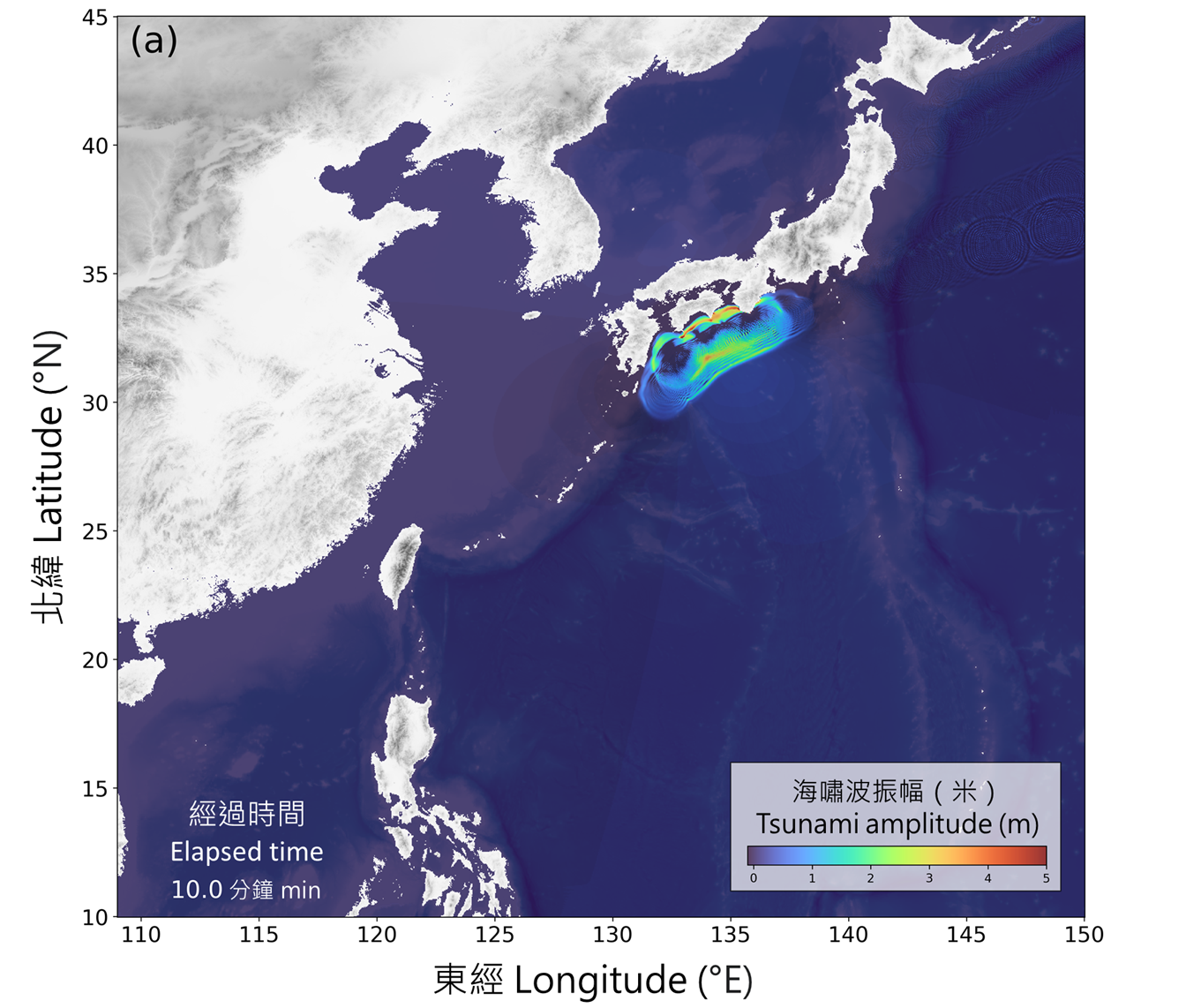
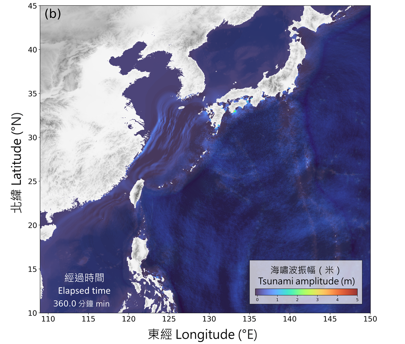
In the event of an earthquake in the South China Sea or the Pacific Ocean, the Hong Kong Observatory (HKO) will conduct tsunami simulations as soon as possible based on seismic parameters, and take observational data into account to assess probable sea level anomalies in Hong Kong. If the earthquake is expected to generate a significant tsunami in Hong Kong and the estimated time of arrival of the tsunami at Hong Kong is within 3 hours, HKO will issue a Tsunami Warning to alert members of the public to take precautions. If a tsunami may reach Hong Kong but the tsunami height at Hong Kong is not likely to be significant, or a significant tsunami is expected to arrive at Hong Kong but the estimated time of arrival of the tsunami is more than 3 hours away, then HKO will issue a Tsunami Information Bulletin to notify members of the public [10]. Citizens travelling abroad should pay attention to the information and warnings about earthquakes and tsunamis issued by local governments [14-15], remain calm, and respond quickly and appropriately.
1 A tsunami with a height of 0.5 m or more above the normal tide level
References: