Freak wind ?
11 June 2010
Gusts of 100 km per hour hit Hong Kong on 22 April, damaging a passenger plane on ground at the airport when three luggage containers slammed into the plane's body. There were also a couple of minor casualties brought by a collapsed wall and a toppled bus stop elsewhere in the territory. But was it really 'freak wind', which we often heard now and then?
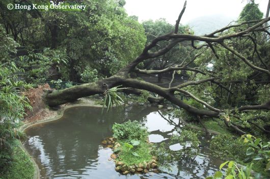
Figure 1.An over 80 cm diameter tree in the Kadoorie Farm and Botanic
Garden toppled during the squally thunderstorms of 9 May 2005.
(Photo taken with the assistance of Kadoorie Farm and Botanic Garden)
The wind is actually called 'Shi Hu Feng' in south China and comes from the northwest quadrant ( hence the name 'northwesterlies' in other parts of the world ). While its origin cannot be traced, the name is commoners' description of the gusts associated with a squall line. A squall line is a cluster of thunderstorms moving in rather rapidly along a line.
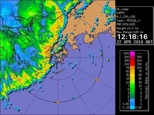
Figure 2.Radar picture of 12.18 p.m. on 22 April 2010. A squall line was crossing
the western part of Hong Kong at that time.
Shi Hu Feng is often accompanied by downpour and thunder, as well as sudden changes in the wind direction coupled with abrupt high winds. The downpour brings lower temperatures, as the cooler air aloft descends to the ground. A fall of several degrees Celsius is quite common. Occasionally a squall line may even bring hail and tornadoes.
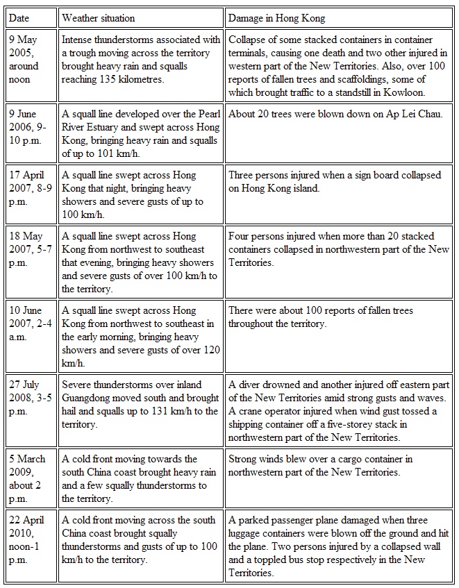
Over the past five years, Hong Kong encountered a total of 8 cases of Shi Hu Feng which brought us significant damage ( see Table 1 ).
Most of the loss of lives and damage to property is avoidable. People need only to tighten the containers, scaffoldings and other loose objects securely. In the picture above, it is believed that most if not all of the containers that got blown off and collapsed were empty, because they were lighter. The news heading said it all: "No natural catastrophe, only human disaster."
Ref.: T.C. Lee (article in HKO's educational resources webpage http://www.hko.gov.hk/education/edu01met/wxphe/ele_squalle.htm)
B.Y. Lee
Table 1.Reports of Shi Hu Feng which have brought significant damage to Hong Kong from 2005 to April 2010


Figure 1.An over 80 cm diameter tree in the Kadoorie Farm and Botanic
Garden toppled during the squally thunderstorms of 9 May 2005.
(Photo taken with the assistance of Kadoorie Farm and Botanic Garden)
The wind is actually called 'Shi Hu Feng' in south China and comes from the northwest quadrant ( hence the name 'northwesterlies' in other parts of the world ). While its origin cannot be traced, the name is commoners' description of the gusts associated with a squall line. A squall line is a cluster of thunderstorms moving in rather rapidly along a line.

Figure 2.Radar picture of 12.18 p.m. on 22 April 2010. A squall line was crossing
the western part of Hong Kong at that time.
Shi Hu Feng is often accompanied by downpour and thunder, as well as sudden changes in the wind direction coupled with abrupt high winds. The downpour brings lower temperatures, as the cooler air aloft descends to the ground. A fall of several degrees Celsius is quite common. Occasionally a squall line may even bring hail and tornadoes.
Over the past five years, Hong Kong encountered a total of 8 cases of Shi Hu Feng which brought us significant damage ( see Table 1 ).
Most of the loss of lives and damage to property is avoidable. People need only to tighten the containers, scaffoldings and other loose objects securely. In the picture above, it is believed that most if not all of the containers that got blown off and collapsed were empty, because they were lighter. The news heading said it all: "No natural catastrophe, only human disaster."
Ref.: T.C. Lee (article in HKO's educational resources webpage http://www.hko.gov.hk/education/edu01met/wxphe/ele_squalle.htm)
B.Y. Lee
Table 1.Reports of Shi Hu Feng which have brought significant damage to Hong Kong from 2005 to April 2010
