Warm Arctic, Cold Continents
29 January 2014
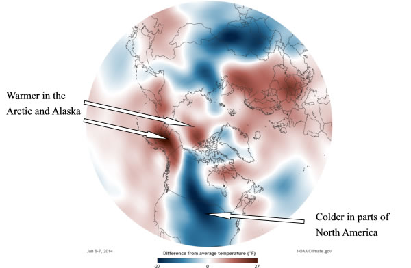
Many parts of the world experienced extreme weather as the planet Earth continued its seasonal march into the new year of 2014 [1]. Winter in the Northern Hemisphere was a wildly fluctuating one (Figure 1). Blasted by frigid air from the polar region, temperatures in many states in the central, eastern and southern parts of the United States were well below freezing. Yet Alaska and the Arctic were abnormally warm. Much of Europe was also exceptionally mild in early January, with France reporting daily maximum temperatures five to nine degrees above the normal values of January. Summer in the Southern Hemisphere, on the other hand, was sizzling hot. The central and eastern interior of Australia was under the grip of a heat wave in early January, and this after Australia reporting a record hot year in 2013.

Figure 1Air temperature (near ground) anomalies for 5-7 January 2014 over the Northern Hemisphere
(the Arctic region at centre) relative to the 1981-2010 average; blue is colder and red is warmer
(source: US National Oceanic and Atmospheric Administration).
It is recognized that climate change can lead to anomalous variations in weather patterns and the likelihood of more extreme weather. Some studies suggest that a warming climate can actually expose the mid-latitude region of the Northern Hemisphere to more incursion of cold air from the Arctic. While this may sound self-contradictory, there is actually a good physical reason behind.
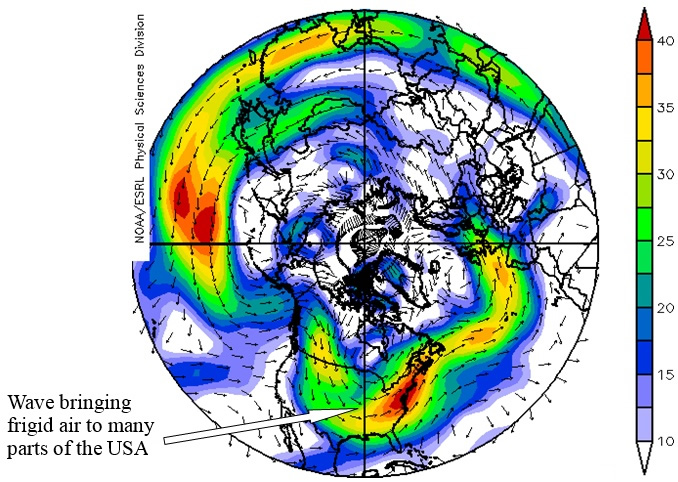
Warming causes the melting of Arctic sea ice and snow cover on land areas, altering the reflectivity of the Earth. Sea ice and snow have much higher reflectivity than ocean and land, and hence are very effective in reflecting sunlight back to space. However, the declining sea ice and snow cover will expose more ocean and land surfaces, increasing the Earth's ability to absorb solar energy. The additional heat will warm the ocean and land, prompting further melting of sea ice and snow cover in a vicious cycle. As a result, the Arctic warms faster than elsewhere in the Northern Hemisphere. The temperature contrast between the polar region and the tropics is reduced, causing the westerly airstream aloft in the Northern Hemisphere to slow down and become more susceptible to wavy meanders. On the west flank of the wave, cold air from the polar region is drawn southwards by the northerly airstream; on the east flank of the wave, warm air from the tropics under a southerly airstream pushes towards regions further north (Figure 2).

Figure 2Winds aloft (about 5 km above ground, unit of wind speed in m/s and indicated by shading) in the Northern Hemisphere
on 5-7 January 2014 (source: US National Oceanic and Atmospheric Administration).
The slow-down of the westerly airstream aloft also favours the establishment of atmospheric blocking in the form of slow-moving anticyclones. The evolution of weather systems then becomes locked into a certain pattern in time and space. Depending on where you are with respect to the blocking set-up, some locations may experience prolonged fine weather, while others may be trapped under a storm corridor in a spell of rainy and gloomy conditions. If blocking occurs in winter, unusually cold or mild weather may persist for days or weeks over the affected regions. One example in recent years that comes to mind is the cold spell experienced by most part of China in early 2008, with cold air from Siberia taking advantage of the time afforded by a blocking situation to spread incessantly southwards all the way to Hong Kong.
Of course, for one single extreme weather event, we can never be sure that it is attributable to climate change. Only a collection of such events in some kind of trends over a period of time can tell the full story. As such, there is always a temptation to just maintain a watching brief, in the hope that the climatologists may turn out to be wrong or, failing that, in the misguided belief that the human race always has the capacity to adapt to climate changes, especially if the full impact we are talking about is, may be, a hundred years or so down the line. But what if the fury of climate change can also be manifested in the form of more frequent extreme weather? We certainly do not want to react too late if the next extreme weather event to hit us is just around the corner!
S M Lee, H W Tong
Reference:
[1] Extreme weather in parts of the world
http://www.wmo.int/pages/mediacentre/news/ExtremeWeatherinpartsoftheworld.html

Figure 1Air temperature (near ground) anomalies for 5-7 January 2014 over the Northern Hemisphere
(the Arctic region at centre) relative to the 1981-2010 average; blue is colder and red is warmer
(source: US National Oceanic and Atmospheric Administration).
It is recognized that climate change can lead to anomalous variations in weather patterns and the likelihood of more extreme weather. Some studies suggest that a warming climate can actually expose the mid-latitude region of the Northern Hemisphere to more incursion of cold air from the Arctic. While this may sound self-contradictory, there is actually a good physical reason behind.
Warming causes the melting of Arctic sea ice and snow cover on land areas, altering the reflectivity of the Earth. Sea ice and snow have much higher reflectivity than ocean and land, and hence are very effective in reflecting sunlight back to space. However, the declining sea ice and snow cover will expose more ocean and land surfaces, increasing the Earth's ability to absorb solar energy. The additional heat will warm the ocean and land, prompting further melting of sea ice and snow cover in a vicious cycle. As a result, the Arctic warms faster than elsewhere in the Northern Hemisphere. The temperature contrast between the polar region and the tropics is reduced, causing the westerly airstream aloft in the Northern Hemisphere to slow down and become more susceptible to wavy meanders. On the west flank of the wave, cold air from the polar region is drawn southwards by the northerly airstream; on the east flank of the wave, warm air from the tropics under a southerly airstream pushes towards regions further north (Figure 2).

Figure 2Winds aloft (about 5 km above ground, unit of wind speed in m/s and indicated by shading) in the Northern Hemisphere
on 5-7 January 2014 (source: US National Oceanic and Atmospheric Administration).
The slow-down of the westerly airstream aloft also favours the establishment of atmospheric blocking in the form of slow-moving anticyclones. The evolution of weather systems then becomes locked into a certain pattern in time and space. Depending on where you are with respect to the blocking set-up, some locations may experience prolonged fine weather, while others may be trapped under a storm corridor in a spell of rainy and gloomy conditions. If blocking occurs in winter, unusually cold or mild weather may persist for days or weeks over the affected regions. One example in recent years that comes to mind is the cold spell experienced by most part of China in early 2008, with cold air from Siberia taking advantage of the time afforded by a blocking situation to spread incessantly southwards all the way to Hong Kong.
Of course, for one single extreme weather event, we can never be sure that it is attributable to climate change. Only a collection of such events in some kind of trends over a period of time can tell the full story. As such, there is always a temptation to just maintain a watching brief, in the hope that the climatologists may turn out to be wrong or, failing that, in the misguided belief that the human race always has the capacity to adapt to climate changes, especially if the full impact we are talking about is, may be, a hundred years or so down the line. But what if the fury of climate change can also be manifested in the form of more frequent extreme weather? We certainly do not want to react too late if the next extreme weather event to hit us is just around the corner!
S M Lee, H W Tong
Reference:
[1] Extreme weather in parts of the world
http://www.wmo.int/pages/mediacentre/news/ExtremeWeatherinpartsoftheworld.html