Local Weather
 Weather Forecast
 Weather Warnings
 Weather for Fishermen
 Weather for Marine
 Weather for Aviation
 Weather Monitoring Imagery
 GIS Weather Service
 Tropical Cyclone
 China Weather
 World Weather
 Climate Information Service
 Warnings & Signals Database
 Statistics of Special Weather Events
 Monthly Weather Summary
 Climate Change
 El Nino and La Nina
 Earthquakes
 Tsunamis
 Tide
Tide Geomagnetism
 Space Weather
 Weather Information for Astronomical Observation
 Interactive Sun Path Diagram
 Astronomical Data
 Interesting Astronomical Phenomena
 Time Services
 Calendar
 Almanac
 Real time Radiation level in Hong Kong
 Understanding Radiation
 Radiation Monitoring, Assessment and Protection
 Environmental Radiation Monitoring Programme
 Daya Bay Contingency Plan
 Related Sites
 Schools
 Travel
 Sports
 Outdoor Photography
 CWOS
CWOS Senior Citizens
 Stargazers
 FoOb
FoOb My Little Observatory
 Educational Resources
 A Tour of Tropical Cyclones
 Cloud Appreciation by Dr Tin
 International Cloud Atlas
 Guided Tour
 Courses and Activities for the Public
 Subscription of e-Bulletins
 Research Forum
 Publications
 International Atomic Energy Agency
 Regional Specialized Meteorological Centre for nowcasting
 Asian Aviation Meteorological Center
 Social Media
 Press Releases
 What's New
 HKO Updates
 LegCo Questions and Answers
 Weather Chit Chat
 Observatory's Blog
 Weather On-Air
 Cool Met Stuff
 Central Briefing
 Tropical Cyclone Report Broadcast
 Observatory's News
 Vacancies
 Tender Notices
 Apps
Apps Personalized Website
 Weather Wizard
 Weather Information in Text
 Weather Information in RSS
 Audio Web Page
 Forms
Forms Open Data
 HKO Corporate Video
 Vision and Mission
 Organizational Structure
 Quality Management
 Hong Kong Observatory – The Facts
 Hong Kong Observatory 2024
 Our Services
 Programme Areas of the Observatory
 History of the Hong Kong Observatory
 Career@HKO
 Visitors Figures
 Hong Kong Observatory Open Day 2025
Tropical Storm Doksuri
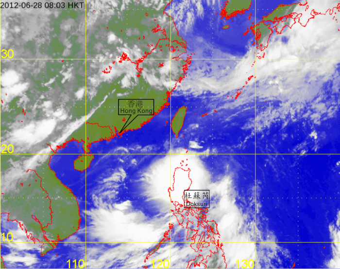
| Infra-red satellite imagery at 8 a.m. on 28 June 2012 of Tropical Storm Doksuri. The centre of Doksuri was located to the northeast of Luzon at that time and at its peak intensity with estimated maximum sustained winds of 85 kilometres per hour near its centre. |
|
[The satellite imagery was originally captured by Multi-functional Transport Satellite-2 (MTSAT-2) of Japan Meteorological Agency (JMA).]
|