Tropical Cyclone Track Probability Forecast
Tropical Cyclone:
“Tropical Cyclone Track Probability Forecast” webpage will be automatically updated within several hours after one of the following situations:
(i) the first issuance of the “Tropical Cyclone Track and Position” by the Observatory (within the area bounded by 7-36 N and 100-140 E); or
(ii) when a tropical cyclone is named in the western North Pacific between 140 E to 180 E and 7 N to 36 N.
(i) the first issuance of the “Tropical Cyclone Track and Position” by the Observatory (within the area bounded by 7-36 N and 100-140 E); or
(ii) when a tropical cyclone is named in the western North Pacific between 140 E to 180 E and 7 N to 36 N.
Probability (%) 

Usage Notes
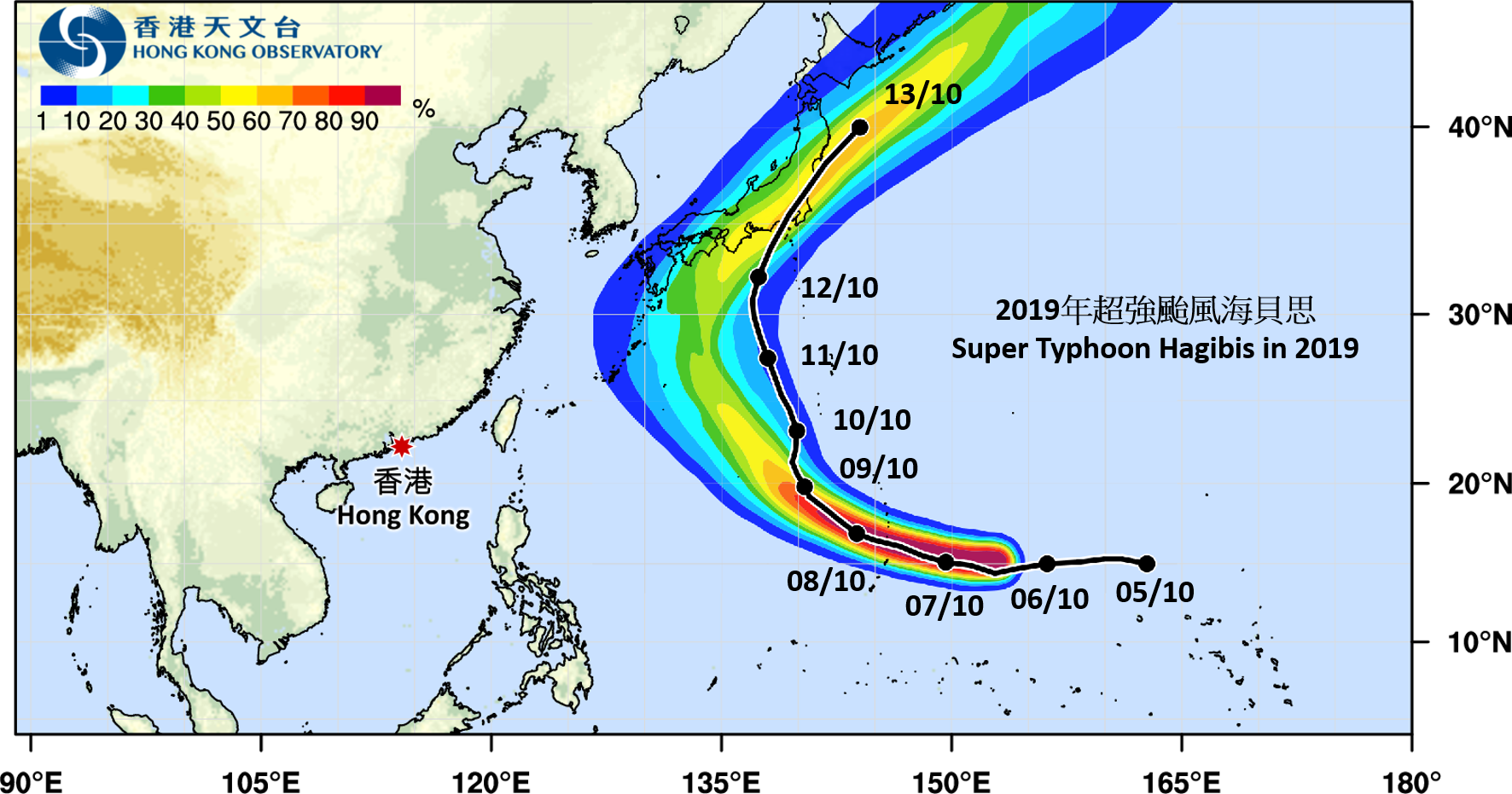
- The “Tropical Cyclone Track Probability Forecast” webpage provides the probability that a tropical cyclone (TC) will pass over a given location in the coming 9 days. Users can refer to the “Track Probability Forecast Map” (TPFM) to appraise the trend of TC movement in the next 9 days.
- The TPFM is automatically generated by computer using data from Ensemble Prediction Systems (EPS) of weather models without manual adjustment. The probability at each map location represents the chance of a tropical cyclone crossing within 120 kilometres of that location in the coming 9 days. Such chances are represented by colours on the TPFM: reddish for higher chance, yellow for medium chance (around 50%) and bluish for lower chance.
- The TPFM will usually be automatically generated within a few hours after: (i) the “Tropical Cyclone Track and Position” information is issued by the Observatory for a new TC (within the area bounded by 7 to 36 degrees north latitude and 100 to 140 degrees east longitude), or (ii) when a TC is named in the western North Pacific between 140 degrees east longitude to 180 degrees east longitude and 7 degrees north latitude to 36 degrees north latitude. Thereafter, the TPFM will be updated once a day around noon.
- For the latest detailed TC information and the 5-day TC track forecast, please refer to the “Tropical Cyclone Track and Position” webpage.
Precautions
- The 5-day TC track issued by forecasters as shown in the “Tropical Cyclone Track and Position” webpage is generated based on various meteorological information, e.g. actual observation data, weather conditions that affect TC movement and data from different computer forecast models (including TC track probability forecast). As the forecast methods are different, the 5-day TC track forecast could be different from this “Tropical Cyclone Track Probability Forecast”.
- When the TCs are still relatively weak or their forecast tracks are much scattered, EPS data of computer models may not allow successful generation of TPFM, suggesting that there is no significant trend in the TC's movement.
- The actual track of a TC may not necessarily coincide with the most probable trend shown on the TPFM, especially in the longer forecast time range (see example below). Please click here for more detailed explanation.
